 |
|
1900
|
|
Hempton Mill
River Wensum |
 |
|
1900
|
|
Hempton watermill
was often known as Goggs' Mill, as the formidable Thomas Goggs owned and
worked the mill between 1854 and 1888, using a combination of water and
steam to power the machinery. |
 |
 |
|
c.1902
|
3rd August 1904 |
 |
|
Mill entrance c.1905 |
|
Hempton Mill was about two miles downstream from Sculthorpe_Mill and about a mile upstream from Fakenham_Mill, which meant that except in times of maximum river flow, the three mills would have had to have been worked in conjunction. When Sculthorpe opened its wheel sluice and started to use its stored head of water, the outflow would head towards Hempton's dam, ready for use before being passed downstream to Fakenham. In order to maximise the efficient use of the available water supply the millers at each of the mills used a system of smoke signals to warn their colleagues whenever the sluices were operated. |
 |
 |
Two versions of a hand coloured postcard from 1906
|
|
In the 1870s and 1880s, Thomas Richard Goggs was a miller, merchant and farmer, with an address at Bridge Street, Fakenham and another at Colkirk. He was living at The Grove, Tunn Street, Fakenham. |
 |
|
Norwich Mercury - 4th March 1843 |
 |
 |
|
c.1906
|
c.1914
|
|
Mr. Richard SALMON, decd. |
 |
|
The flood of August 1912 - mill left of centre skyline
|
|
HEMPTON WATER MILL |
 |
 |
c.1915 |
1921 |
|
To Millers |
|
The foundry at Gt Walsingham held the pattern for the crown wheel. |
 |
|
c.1922 |
 |
 |
1921 |
c.1925 |
 |
c.1925 |
 |
 |
c.1933 |
Postcard with handwritten date 15th August 1934 |
After
the mill closed the Marchioness Townshend of Raynham announced her
intention of establishing a public tea garden, provided the local authorities
proceeded with their plan to lay down a bathing pool in the River Wensum
nearby. The authorities did not proceed with their plan to build a swimming pool and so the Marchioness did not proceed with her plans either. |
 |
 |
|
Part of the structure and the brick base still standing 26th March 1958
|
|
 |
 |
Angler on left - Micky Quelch; angler on right - Mervyn Edge Eastern Daily Press photographs - 25th September 1953 |
|
 |
EDP photo - 1953 |
 |
c.1958 |
|
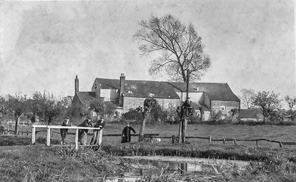
After the war, the mill became derelict and was finally demolished in June 1954 by the East Suffolk and Norfolk Drainage Board to improve land drainage in the area by lowering the river level by 1½ to 2 feet. Workmen only took a day to demolish Goggs' Mill,
one of the best known landmarks in rural Fakenham. The work was done
on the orders of the East Suffolk and Norfolk River Board, who bought
the mill some time before. By 1958 all that remained were the mill house and brick foundations of the mill. Fakenham Rotary Club then levelled the banks and sowed grass to provide a riverside walk. |
When I was a child at Fakenham, we would often walk down to the river via a road flanked with poplar trees, locally known (then) as the 'Unter den Linden'. Before they altered the road, there used to be a bridge and a ford, as well as an extra stream with a footbridge, where we used to stand and catch tadpoles (though I never used to know what to do with the wretched things once I'd got them in the jar).
The river, the Wensum, was a pale shadow of its former self. One old great-uncle, who had lived in Fakenham all his life, once told me that pleasure craft used to go along the river as far as Gogg's Mill. Though where from, and how big, I have no idea (at the time I imagined something like the Golden Galleon!!).
Linda Steward - 1st September 2005 |
When browsing I came upon the Goggs mill. It brought a smile to my face as I knew the old mill well as I born and bred in Fakenham, Quaker Lane, which was only a short distance from the mill by the still in use foot path from Hall Staithe to the location of where the mill was in the 1951 photos. Where the trees are to the right my older brother and friends use to dive from the trees into the mill pond which was very deep then. ALL of us in our family learnt to swim in the area of the mill and in those days 1950s and 1960s the mill area was very popular with so many of us who lived in the town at that time. One incident that did not go down too well with the local police was that one day during the summer holidays myself and two friends were trying to dam up the river on the down side flow of water by the arches in the mill and we discovered LOADS of ammunition small stuff and large stuff which we reported to the police. They were fed up because we were creating a load of paper work for them, I also think the incident was reported in the local paper, the police believe the ammunition was dumped in the mill pond after the 2nd WW by the local home guard. Thanks for the photos many many happy times were spent by the river and the Goggs mill. |
I always thought that the ammunition found next the bridge was from a army lorry which crashed through the bridge. The last part of Goggs mill still standing were the stables. I remember changing my clothes in there when I was young. |
 |
 |
|
Brickwork
remains on the left bank October 1982
|
Millpond 1977 |
 |
|
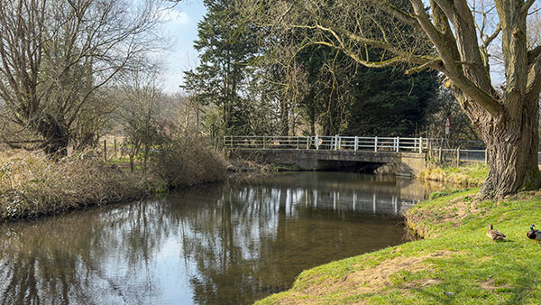
Millpond 9th March 2003
|
Mills |
|
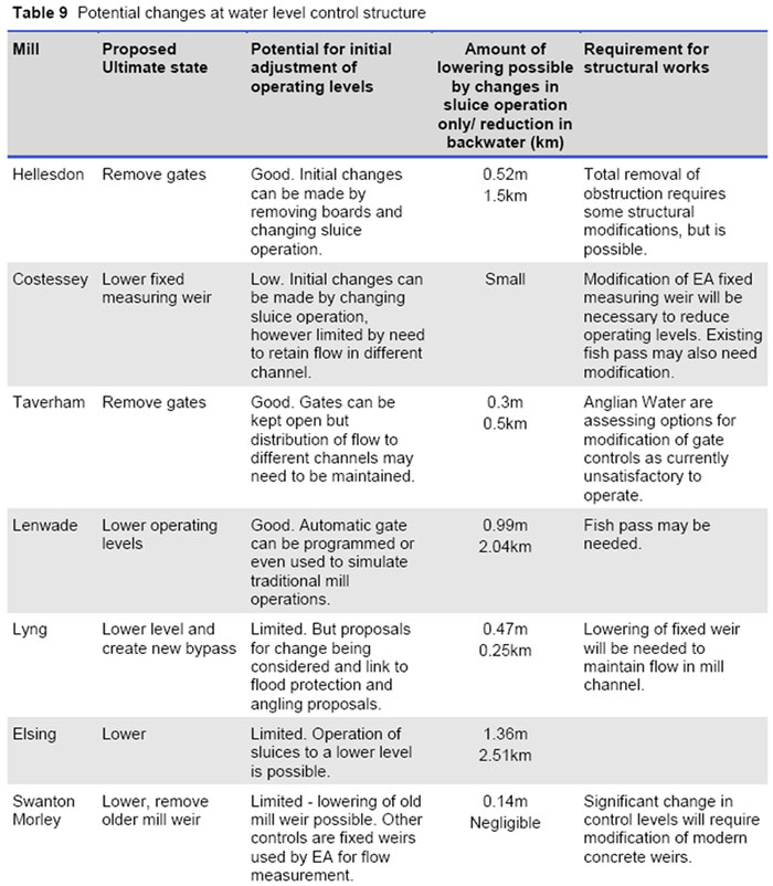
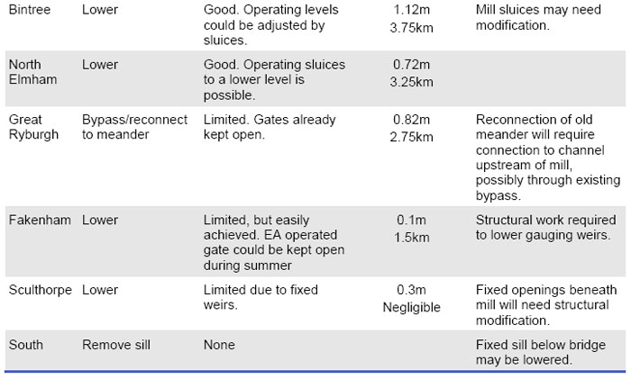
6.16 The mill structures have a profound influence on the river system in the Wensum catchment. If high retained water levels continue upstream of the mills, they would form a significant constraint on the effectiveness of river restoration. Physical modifications at mill sites should aim to restore a more natural longitudinal profile to the river and to remove or reduce physical barriers to the movement of fish and wildlife. Whilst historically a number of mills have been in existence for centuries these have always very actively stored and released water and the cessation of working of the mills in combination with dredging has had a significant impact. 6.17 The recommended actions at mill structures are shown in Table 9. At a number of sites there is no mill building and removal of water level control structures would be the desired course of action. However, often there are multiple channels at a mill site and it is likely that some hydraulic controls would be needed to maintain a split of flows to all channels. These would probably take the form of a fixed crest and a natural chute that would allow the passage of fish and woody debris. At locations where the water level control structures are part of the historic mill building, there is often a variety of passageways and the best way to lower levels will need to be identified using more detailed survey. Initial action can be taken at low cost by merely adjusting operating levels using the available gates and stop boards. The reduction in head that could be achieved at a typical dry weather flow is also summarised in Table 9. The estimated maximum reduction in backwater length through changing the operational level of the sluices (that is, without the need for major engineering works) is 18km. This would reduce the length of the River Wensum SSSI affected by backwater from mills from 67% to 40%. To achieve this it would be necessary to ensure that no channels downstream of gates or fixed weirs are affected, but this could be a cost effective start to the Wensum restoration. 6.18 It is likely that at some locations, where the channel course has been altered and the mill channel is significantly higher than the natural channel, the main flow could be diverted upstream of the current mill location. Maintaining some flow to the original mill weir is likely to be preferable for aesthetic and heritage reasons, so by-passing is likely to be required in conjunction with lowering of the mill weir. Sites where such a solution is envisaged are at Great Ryburgh and Lyng. 6.19 The control structures at Costessey, Swanton Morley and Fakenham are used for flow gauging by the Environment Agency. Lowering these weirs may mean that the existing gauging arrangements will need to be replaced by other methods, such as ultrasonic techniques. The weir on the main channel at Swanton Morley has a two stage drop and a significant reduction in water level could be achieved there without affecting flow gauging through the bridge. 6.20 A former mill known as Gogg‟s Mill near to Fakenham was removed as part of the drainage improvement works of the 1950s. The channel upstream of the mill has narrowed significantly through the accretion of silt berms, and provides a good case study of the extent to which natural recovery can help restore natural river form and function. 6.21 As part of the River Wensum Water Level Management Plan being prepared by Entec (2007) the views of some private owners on changes in operating level have been canvassed. In broad terms this is not opposed, but there is concern to maintain an attractive setting incorporating some mill pond in line with the historical context particularly at: 1) Elsing 2) Great Ryburgh 3) Bintree 4) North Elmham 5) Lenwade. 6.22 A reduction in the retained water level at mills may constrain the ability to direct water through all the existing channels at mill sites, should this still be required, there may be a need to carry out physical modifications to some of the subsidiary water level control structures. River Wensum Restoration Strategy - Natural England, 26th June 2009 |
 |
25th March 2025 |
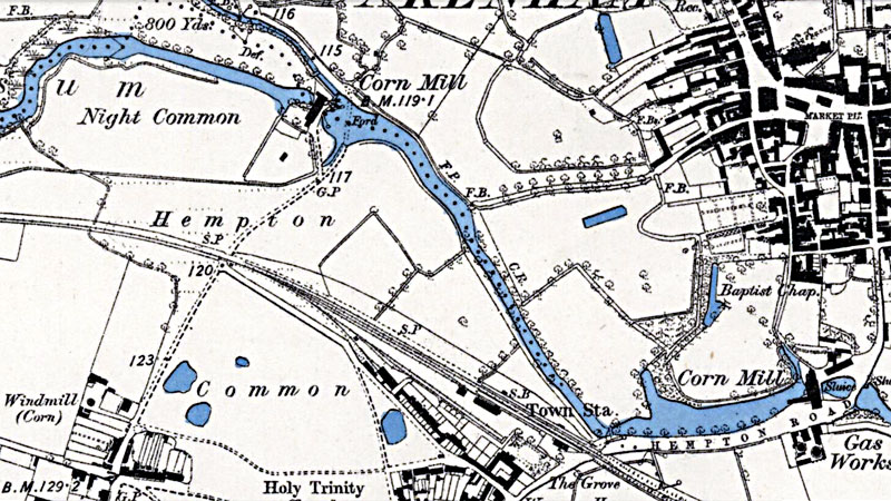 |
O. S. 6" Map 1885 (not to scale) |
 |
O. S. 25" Map 1885 (not to scale) |
The dotted parish boundary line running through and to the north of Hempton mill on the above map, probably follows the line of the original watercourse before it was moved south and straightened in order to accommodate the mill. |
 |
|
O.S. Map 2005 Image reproduced under licence from Ordnance Survey |
White's 1854: Shakespeare Bell, millwright |
|
Faden's map
1797: Mill
Kelly's 1892: Thomas Richard Goggs, miller (steam & water), corn merchant & farmer; res. Fakenham Kelly's 1896: Thomas Richard Goggs, miller (steam & water), corn merchant & farmer; res. Fakenham |
If you have any memories, anecdotes or photos please let us know and we may be able to use them to update the site. By all means telephone 07836 675369 or
|
| Nat Grid Ref TF91382962 | Copyright © Jonathan Neville 2003 |